
1959 Map of Millett
USGS Topo · Published 1959About this map
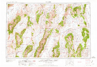
Austin and its neighboring settlement of Millett serve as central points in this mid-century look at the high desert and mountain basins of central Nevada. The landscape is defined by the massive north-south corridors of the Reese River Valley, Big Smoky Valley, and Monitor Valley, which separate the towering peaks of the Toiyabe Range and the Shoshone Mountains. This map captures a moment when the region's economy relied heavily on isolated cattle ranches and mining operations, evidenced by the many family-named outposts such as McLeod Ranch, Roberts Creek Ranch, and Grass Valley Ranch.
Find a feature on this map
104 named features on this map. Tap any name to fly to it.
Don’t see what you’re looking for? This feature index may not catch every label — zoom into the map to look around manually.
Map Details
Editions of this 1959 Millett Map
2 editions found
Other maps of this area

1907 · Tonopah
USGS Topo · 1:250,000

1908 · Tonopah
USGS Topo · 1:250,000

1908 · Carson Sink
USGS Topo · 1:250,000

1909 · Hawthorne
USGS Topo · 1:250,000

1910 · Carson Sink
USGS Topo · 1:250,000

1911 · Hawthorne
USGS Topo · 1:250,000

1915 · Hawthorne
USGS Topo · 1:250,000

1926 · Roberts Mountains
USGS Topo · 1:250,000

1929 · Roberts Mountains
USGS Topo · 1:250,000

1931 · Lovelock
USGS Topo · 1:250,000