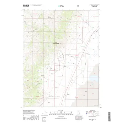
2018 Map of Millett Ranch
USGS Topo · Published 2018About this map
Millett Ranch sits at the base of the steep eastern slopes of the Toiyabe Range, overlooking the expansive basin of the Big Smoky Valley. This landscape is defined by the sharp transition from high mountain peaks to arid valley floor, where seasonal drainage from Gendron Creek, McLeod Cr, and Decker Cr flows toward an Alkali Flat. The map documents a network of rugged backcountry routes, including the high-elevation Toiyabe Crest Natl Rec Trail and the historic Fremont Trl tracking along the valley edge. Notable landmarks such as Mcleods Ranch Spring and the Indian Burial Grd Rd point to the area's long history of human transit and survival in the high desert. Within the Toiyabe National Forest, numerous canyons like Trail Canyon and Park Canyon provide access to the wilderness surrounding Toiyabe Range Peak.
Find a feature on this map
35 named features on this map. Tap any name to fly to it.
Don’t see what you’re looking for? This feature index may not catch every label — zoom into the map to look around manually.
Map Details
Editions of this 2018 Millett Ranch Map
This is the sole edition of this map. No revisions or reprints were ever made.
Other maps of this area

1907 · Tonopah
USGS Topo · 1:250,000

1908 · Tonopah
USGS Topo · 1:250,000

1955 · Millett
USGS Topo · 1:250,000

1956 · North Shoshone Peak
USGS Topo · 1:62,500

1956 · Millett Ranch
USGS Topo · 1:62,500

1956 · Tonopah
USGS Topo · 1:250,000

1959 · Tonopah
USGS Topo · 1:250,000

1959 · Millett
USGS Topo · 1:250,000

1962 · Tonopah
USGS Topo · 1:250,000

1971 · Carvers NW
USGS Topo · 1:24,000