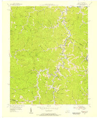
1954 Map of Milo
USGS Topo · Published 1955About this map
The Tug Fork defines the rugged border between Kentucky and West Virginia in this 1954 survey, winding past the village of Clifford and the isolated Camp Gideon Childrens Home. The landscape is dominated by a dense network of ridges and hollows, where local life centered around small creek-bottom settlements and numerous mountain schools like Cherryville Sch, Peach Orchard Sch, and Buffalo Horn Sch. A distinct extractive economy is visible through the Coalfield label and numerous gas wells noted in the margin, while elevated points like Coon Knob are marked by the Orchard Lookout Tower. This map captures a particular moment in the mid-20th century before rural school consolidation and shifting energy markets transformed these Appalachian communities, preserving the locations of family-centric landmarks like the Stidham PO and Justice Ch.
Find a feature on this map
82 named features on this map. Tap any name to fly to it.
Don’t see what you’re looking for? This feature index may not catch every label — zoom into the map to look around manually.
Map Details
Editions of this 1954 Milo Map
4 editions found
Other maps of this area

1886 · Prestonsburg
USGS Topo · 1:125,000

1887 · Warfield
USGS Topo · 1:125,000

1891 · Warfield
USGS Topo · 1:125,000

1892 · Prestonsburg
USGS Topo · 1:125,000

1892 · Huntington
USGS Topo · 1:125,000

1898 · Huntington
USGS Topo · 1:125,000

1903 · Kenova
USGS Topo · 1:125,000

1904 · Kenova
USGS Topo · 1:125,000

1909 · Wayne
USGS Topo · 1:62,500

1910 · Naugatuck
USGS Topo · 1:48,000