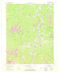
1954 Map of Milo
USGS Topo · Published 1978About this map
Rockcastle Creek and the Tug Fork define the movement of life through this portion of Martin and Lawrence Counties. Small communities like Milo and Stidham PO serve as hubs for a landscape deeply etched by the coal industry, where strip mines have reshaped the hillsides above the winding creek branches. The area is dense with local social landmarks, including numerous rural schools like Buffalo Horn Sch and Castle Sch, alongside Old Friendship Ch and the Camp Gideon Childrens Home. High points like Coon Knob and the Orchard Lookout Tower provided vantage points over the narrow hollows and numerous cemeteries that dot the family-held lands along Pruitt Creek and Lick Creek. This 1954 survey, with 1970s revisions, illustrates the persistent rural settlement pattern of eastern Kentucky during the height of its mid-century industrial extraction era.
Find a feature on this map
81 named features on this map. Tap any name to fly to it.
Don’t see what you’re looking for? This feature index may not catch every label — zoom into the map to look around manually.
Map Details
Editions of this 1954 Milo Map
4 editions found
Other maps of this area

1886 · Prestonsburg
USGS Topo · 1:125,000

1887 · Warfield
USGS Topo · 1:125,000

1891 · Warfield
USGS Topo · 1:125,000

1892 · Prestonsburg
USGS Topo · 1:125,000

1892 · Huntington
USGS Topo · 1:125,000

1898 · Huntington
USGS Topo · 1:125,000

1903 · Kenova
USGS Topo · 1:125,000

1904 · Kenova
USGS Topo · 1:125,000

1909 · Wayne
USGS Topo · 1:62,500

1910 · Naugatuck
USGS Topo · 1:48,000