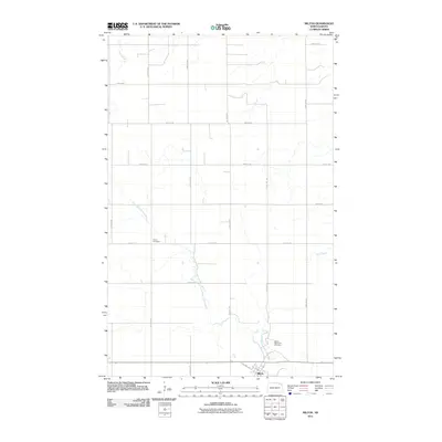
2011 Map of Milton
USGS Topo · Published 2011About this map
Milton sits at the southern edge of this North Dakota landscape, serving as a hub for the surrounding agricultural prairie during the early 21st century. The town's grid, including Oakland Ave and Poplar St, is bounded by the winding North Branch Park River. Local genealogy and land use patterns are anchored by burial grounds such as the Milton Memorial Cemetery just east of town and Dovre Cemetery to the north. The terrain is defined by a series of drainage systems, including the Tongue River in the northwest and Cart Creek to the east, which cut through the strictly organized section-line road network. This survey illustrates the persistent rural structure of Cavalier County, where long-established names remain tied to the specific waterways and cemetery sites that have served this community for generations.
Find a feature on this map
22 named features on this map. Tap any name to fly to it.
Don’t see what you’re looking for? This feature index may not catch every label — zoom into the map to look around manually.
Map Details
Editions of this 2011 Milton Map
This is the sole edition of this map. No revisions or reprints were ever made.
Other maps of this area

1918 · Walhalla
USGS Topo · 1:62,500

1943 · Walhalla
USGS Topo · 1:62,500

1952 · Thief River Falls
USGS Topo · 1:250,000

1953 · Devils Lake
USGS Topo · 1:250,000

1956 · Thief River Falls
USGS Topo · 1:250,000

1956 · Devils Lake
USGS Topo · 1:250,000

1957 · Thief River Falls
USGS Topo · 1:250,000
1964 · Concrete
USGS Topo · 1:24,000
1964 · Hanks Corner
USGS Topo · 1:24,000

1967 · Thief River Falls
USGS Topo · 1:250,000