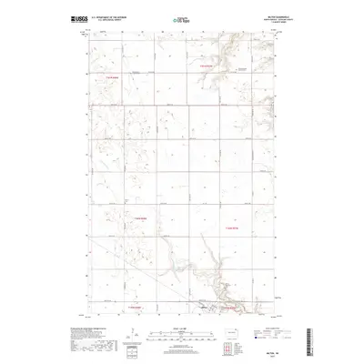
2017 Map of Milton
USGS Topo · Published 2017About this map
Milton serves as the primary hub in this corner of Cavalier County, where the grid of sections meets the winding paths of the N Br Park River and Cart Cr. The landscape is defined by its deep Scandinavian and Icelandic roots, evidenced by several distinct burial grounds that mark the heritage of the early prairie pioneers. The Fjalla Icelandic Lutheran Cem and North Dovre Lutheran Cem sit among the northern sections, while Dovre Cem and Saint Clothilds Cem are situated further south. Near the town site, the Milton Memorial Cem overlooks the local drainage. These sites, often located at intersections like 84th St NE and Oakland Ave, provide essential landmarks for genealogists tracking the settlement patterns of these rural townships. The northernmost reaches are crossed by the Tongue River, while a dense network of numbered county roads connects the dispersed farmsteads.
Find a feature on this map
28 named features on this map. Tap any name to fly to it.
Don’t see what you’re looking for? This feature index may not catch every label — zoom into the map to look around manually.
Map Details
Editions of this 2017 Milton Map
This is the sole edition of this map. No revisions or reprints were ever made.
Other maps of this area

1918 · Walhalla
USGS Topo · 1:62,500

1943 · Walhalla
USGS Topo · 1:62,500

1952 · Thief River Falls
USGS Topo · 1:250,000

1953 · Devils Lake
USGS Topo · 1:250,000

1956 · Thief River Falls
USGS Topo · 1:250,000

1956 · Devils Lake
USGS Topo · 1:250,000

1957 · Thief River Falls
USGS Topo · 1:250,000
1964 · Concrete
USGS Topo · 1:24,000
1964 · Hanks Corner
USGS Topo · 1:24,000

1967 · Thief River Falls
USGS Topo · 1:250,000