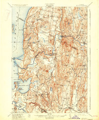
1915 Map of Milton
USGS Topo · Published 1931About this map
Lake Champlain forms the western boundary of this Vermont landscape, where the Lamoille River and Winooski River cut through the undulating hills of Chittenden and Franklin counties. The Central Vermont railroad dictates the corridor of growth, connecting established hubs like Milton and East Georgia. Smaller, scattered settlements such as Checkerberry Village and Georgia Center are defined by a network of one-room schoolhouses, including School No 10 and King School, serving a rural agricultural population.
Find a feature on this map
96 named features on this map. Tap any name to fly to it.
Don’t see what you’re looking for? This feature index may not catch every label — zoom into the map to look around manually.
Map Details
Editions of this 1915 Milton Map
5 editions found
Other maps of this area

1894 · Plattsburg
USGS Topo · 1:62,500

1895 · Rouse Point
USGS Topo · 1:62,500

1895 · Willsboro
USGS Topo · 1:62,500

1906 · Plattsburg
USGS Topo · 1:62,500

1906 · Burlington
USGS Topo · 1:62,500

1907 · Rouse Point
USGS Topo · 1:62,500

1913 · Milton
USGS Topo · 1:48,000

1914 · St. Albans
USGS Topo · 1:48,000

1915 · Milton
USGS Topo · 1:62,500

1916 · St. Albans
USGS Topo · 1:62,500