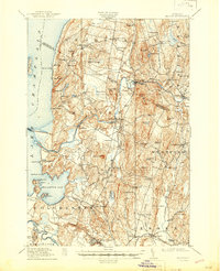
1915 Map of Milton
USGS Topo · Published 1944About this map
Lake Champlain dominates the western edge of this 1913 survey, where the Sand Bar Bridge connects the mainland to the islands beyond. The landscape is defined by the winding course of the Lamoille River and the Winooski River, which supported early industrial and agricultural nodes like Milton and Westford. The presence of the Central Vermont railroad line facilitates the connection between these rural centers, passing through East Georgia. Local social structures are clearly visible through the numerous numbered schoolhouses, such as School No 11A and School No 13, alongside uniquely named institutions like the Hardscrabble School. To the south, the military presence at Fort Ethan Allen stands near the burgeoning communities of Colchester and Essex Center, while the coastline is dotted with seasonal camps like Camp Winnisquam and Camp Watson along the shores of Malletts Bay.
Find a feature on this map
102 named features on this map. Tap any name to fly to it.
Don’t see what you’re looking for? This feature index may not catch every label — zoom into the map to look around manually.
Map Details
Editions of this 1915 Milton Map
5 editions found
Other maps of this area

1894 · Plattsburg
USGS Topo · 1:62,500

1895 · Rouse Point
USGS Topo · 1:62,500

1895 · Willsboro
USGS Topo · 1:62,500

1906 · Plattsburg
USGS Topo · 1:62,500

1906 · Burlington
USGS Topo · 1:62,500

1907 · Rouse Point
USGS Topo · 1:62,500

1913 · Milton
USGS Topo · 1:48,000

1914 · St. Albans
USGS Topo · 1:48,000

1915 · Milton
USGS Topo · 1:62,500

1916 · St. Albans
USGS Topo · 1:62,500