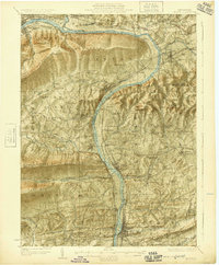
1924 Map of Milton
USGS Topo · Published 1924About this map
The West Branch Susquehanna River carves a deep valley between the ridges of central Pennsylvania, anchoring a corridor of industry and agriculture in the early 1920s. Heavy rail infrastructure from the Pennsylvania RR and Reading RR follows the riverbanks, connecting industrial centers like Milton, Watsontown, and Montgomery. This survey captures a landscape defined by sharp topographic contrasts, where the steep slopes of Bald Eagle Mountain and South White Deer Ridge overlook fertile valleys dotted with numerous rural institutions. The map records a dense network of one-room schools, such as the Stony Batter School and Five Point School, alongside landmarks of local heritage like the Stone Church and St Johns Church. Small-scale industrial history is evident at the Old Furnace on White Deer Creek, providing a detailed look at the region's development before mid-century modernization.
Find a feature on this map
115 named features on this map. Tap any name to fly to it.
Don’t see what you’re looking for? This feature index may not catch every label — zoom into the map to look around manually.
Map Details
Editions of this 1924 Milton Map
4 editions found
Other maps of this area

1892 · Shamokin
USGS Topo · 1:62,500

1893 · Sunbury
USGS Topo · 1:62,500

1893 · Shamokin
USGS Topo · 1:62,500

1921 · Williamsport
USGS Topo · 1:48,000

1921 · Trout Run
USGS Topo · 1:62,500

1923 · Trout Run
USGS Topo · 1:62,500

1923 · Williamsport
USGS Topo · 1:62,500

1924 · Milton
USGS Topo · 1:62,500

1927 · Eagles Mere
USGS Topo · 1:48,000

1930 · Warrensville
USGS Topo · 1:62,500
Featured Places
- Williamsport, PA
- South Williamsport, PA
- Montoursville, PA
- White Deer Township, PA
- Kenmar, Loyalsock Township