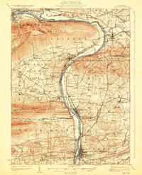
1924 Map of Milton
USGS Topo · Published 1924About this map
The West Branch Susquehanna River serves as the central artery of this 1920s landscape, flanked by the steep ridgelines of Bald Eagle Mountain and North White Deer Ridge. This era shows a high density of rural education, with dozens of family-named schoolhouses such as Stony Batter School and Bites Peak School serving the farming communities in White Deer Valley and the surrounding hills. The industrial and transportation corridor follows the riverbanks, where the Pennsylvania and Reading railroads connect established manufacturing hubs like Milton and Watsontown. Further north, Muncy and Montgomery anchor the river bends, while smaller hamlets like Alvira and Dewart appear in their pre-war configurations. The landscape transitions from the flat river valley into the rugged Nittany Mtn and Buffalo Mtn, where landmarks like the Shaffers Path Tower and the Old Furnace on White Deer Creek point to a history of forest surveillance and early industry.
Find a feature on this map
123 named features on this map. Tap any name to fly to it.
Don’t see what you’re looking for? This feature index may not catch every label — zoom into the map to look around manually.
Map Details
Editions of this 1924 Milton Map
4 editions found
Other maps of this area

1892 · Shamokin
USGS Topo · 1:62,500

1893 · Sunbury
USGS Topo · 1:62,500

1893 · Shamokin
USGS Topo · 1:62,500

1921 · Williamsport
USGS Topo · 1:48,000

1921 · Trout Run
USGS Topo · 1:62,500

1923 · Trout Run
USGS Topo · 1:62,500

1923 · Williamsport
USGS Topo · 1:62,500

1924 · Milton
USGS Topo · 1:62,500

1927 · Eagles Mere
USGS Topo · 1:48,000

1930 · Warrensville
USGS Topo · 1:62,500
Featured Places
- Williamsport, PA
- South Williamsport, PA
- Montoursville, PA
- White Deer Township, PA
- Kenmar, Loyalsock Township