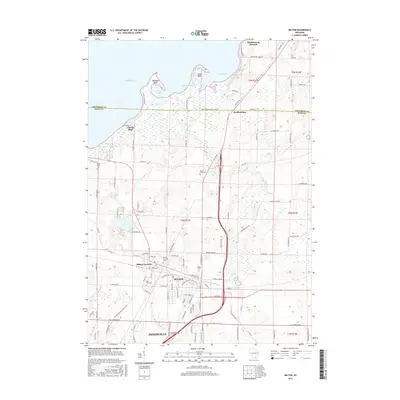
2016 Map of Milton
USGS Topo · Published 2016About this map
Milton and its neighboring Milton Junction serve as the primary hubs in this southern Wisconsin landscape, situated just north of the expanding Janesville area. The map illustrates a region defined by its glacial hydrology, where the northern border is dominated by the expansive Lake Koshkonong and its various inlets like Lautz Bay, Bingham's Bay, and Haights Bay. Between these waters and the urban centers lie several small, localized basins including Clear Lake, Grass Lake, and the Cranberry Marsh. Local history is deeply embedded in the terrain through numerous dedicated sites such as Milton Junction Cem, Saint Mary Cem, and the Otter Creek Cem. Notable landmarks along the lake shore, such as Thiebeau Point and Stony Point, provide context for the shoreline development and natural features that have shaped Rock County's recreation and settlement patterns over the decades.
Find a feature on this map
111 named features on this map. Tap any name to fly to it.
Don’t see what you’re looking for? This feature index may not catch every label — zoom into the map to look around manually.
Map Details
Editions of this 2016 Milton Map
This is the sole edition of this map. No revisions or reprints were ever made.
Other maps of this area

1890 · Stoughton
USGS Topo · 1:62,500

1891 · Koshkonong
USGS Topo · 1:62,500

1891 · Janesville
USGS Topo · 1:62,500

1893 · Janesville
USGS Topo · 1:62,500

1893 · Shopiere
USGS Topo · 1:62,500

1894 · Koshkonong
USGS Topo · 1:62,500

1906 · Koshkonong
USGS Topo · 1:62,500

1954 · Rockford
USGS Topo · 1:250,000

1955 · Rockford
USGS Topo · 1:250,000

1958 · Rockford
USGS Topo · 1:250,000