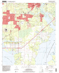
1994 Map of Milton South
USGS Topo · Published 2000About this map
The Blackwater River and Escambia Bay define the industrial and residential development of southern Santa Rosa County in the mid-1990s. The historic riverfront town of Milton and the nearby community of Bagdad serve as the primary hubs, with many smaller neighborhoods like Galt City and Avalon Beach extending toward the coast. Local family history is preserved in numerous burial grounds, including the Milton Cem and Black Hammock Cem, while spiritual life is anchored by churches such as Wilson Mem Ch and Mt Bethel Ch. The landscape shows a mix of maritime industry and aviation history, evidenced by an Abandoned Airfield and numerous boat ramps. The south-central portion of the map is dominated by the sprawling wetlands of the Yellow River Marsh State Aquatic Preserve, where dozens of winding waterways like Whiteoak Bayou and Trout Bayou feed into the larger bays.
Find a feature on this map
67 named features on this map. Tap any name to fly to it.
Don’t see what you’re looking for? This feature index may not catch every label — zoom into the map to look around manually.
Map Details
Editions of this 1994 Milton South Map
This is the sole edition of this map. No revisions or reprints were ever made.
Other maps of this area

1920 · Milton
USGS Topo · 1:62,500

1921 · Holley
USGS Topo · 1:62,500

1921 · Pensacola
USGS Topo · 1:62,500

1934 · Harold
USGS Topo · 1:62,500

1936 · Holley
USGS Topo · 1:48,000

1937 · Harold
USGS Topo · 1:62,500

1938 · Holley
USGS Topo · 1:62,500

1938 · Harold
USGS Topo · 1:62,500

1941 · Pensacola
USGS Topo · 1:62,500

1941 · Milton
USGS Topo · 1:62,500