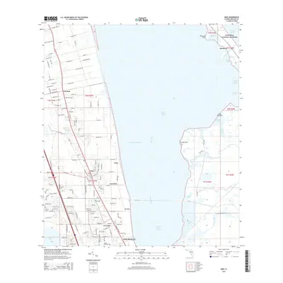
2015 Map of Mims
USGS Topo · Published 2015About this map
Titusville and the citrus-growing corridor of the Space Coast are captured here just north of the city center. This area is defined by the expansive Indian River Lagoon and its connection to the Mosquito Lagoon via the historic Haulover Canal. The landscape shows a mix of residential development and preserved natural shoreline within the Canaveral National Seashore. Key local settlements such as Mims, East Mims, and La Grange line the western shore, clustered along the Fec railroad line and the Intracoastal Waterway. The presence of Arthur Dunn Air Park and numerous small coves like Bairs Cove and Duckroost Cove illustrates the region's historical reliance on both aviation and maritime transit. Smaller named places like Jay Jay and Wiley provide specific points of interest for local history and genealogy researchers tracking the growth of Brevard County.
Find a feature on this map
137 named features on this map. Tap any name to fly to it.
Don’t see what you’re looking for? This feature index may not catch every label — zoom into the map to look around manually.
Map Details
Editions of this 2015 Mims Map
This is the sole edition of this map. No revisions or reprints were ever made.
Other maps of this area
1949 · Oak Hill
USGS Topo · 1:24,000
1949 · Pardon Island
USGS Topo · 1:24,000
1949 · Orsino
USGS Topo · 1:24,000
1949 · Titusville
USGS Topo · 1:24,000
1949 · Wilson
USGS Topo · 1:24,000
1949 · Mims
USGS Topo · 1:24,000
1950 · Maytown
USGS Topo · 1:24,000
1950 · Aurantia
USGS Topo · 1:24,000
1951 · Orsino
USGS Topo · 1:24,000
1952 · Mims
USGS Topo · 1:24,000