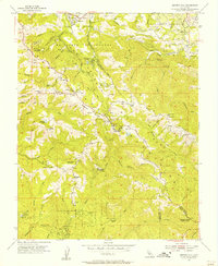
1955 Map of Mindego Hill
USGS Topo · Published 1957About this map
The Santa Cruz Mountains define this mid-century landscape where ranching life and early conservation efforts met along the divide of San Mateo and Santa Clara counties. In the mid-1950s, the terrain was characterized by family-named holdings such as Skyline Ranch and Big Dipper Ranch, while education was already shifting as evidenced by the Purisima School (Aban'd) and Alpine School (Aban'd). The southern portion of the map centers on the protected lands of Portola State Park, where Peters Creek and Pescadero Creek flow through the redwoods. Evidence of earlier industry is found at the Page Mill (Site), marking the historic lumbering routes that once traversed these ridges. From the heights of Mindego Hill down to the remote Devils Canyon, the map traces a network of winding roads like Skyline Boulevard and Alpine Road that connected these upland communities.
Find a feature on this map
68 named features on this map. Tap any name to fly to it.
Don’t see what you’re looking for? This feature index may not catch every label — zoom into the map to look around manually.
Map Details
Editions of this 1955 Mindego Hill Map
2 editions found
Other maps of this area

1897 · Palo Alto
USGS Topo · 1:62,500

1899 · Palo Alto
USGS Topo · 1:62,500

1902 · Santa Cruz
USGS Topo · 1:125,000

1940 · Halfmoon Bay
USGS Topo · 1:62,500

1940 · Ano Nuevo
USGS Topo · 1:62,500

1941 · Ano Nuevo Pt.
USGS Topo · 1:62,500

1941 · Palo Alto
USGS Topo · 1:62,500

1942 · Ano Nuevo
USGS Topo · 1:62,500

1943 · Palo Alto
USGS Topo · 1:62,500

1943 · Halfmoon Bay
USGS Topo · 1:62,500