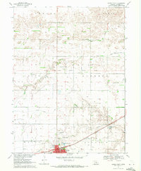
1969 Map of Minden North
USGS Topo · Published 1971About this map
Minden anchors the southern edge of this Central Nebraska landscape, where the agricultural plains are etched by the Old Fort Kearney Military Reservation Boundary. The survey reveals a complex water management system necessary for prairie farming, featuring the Adams County Canal (Abandoned) and various Canal segments that cut across the townships of Logan and Liberty.
Find a feature on this map
31 named features on this map. Tap any name to fly to it.
Don’t see what you’re looking for? This feature index may not catch every label — zoom into the map to look around manually.
Map Details
Editions of this 1969 Minden North Map
This is the sole edition of this map. No revisions or reprints were ever made.
Other maps of this area

1894 · Kearney
USGS Topo · 1:62,500

1894 · Minden
USGS Topo · 1:62,500

1896 · Holdrege
USGS Topo · 1:125,000

1896 · Kearney
USGS Topo · 1:125,000

1896 · Wood River
USGS Topo · 1:125,000

1897 · Red Cloud
USGS Topo · 1:125,000

1955 · Grand Island
USGS Topo · 1:250,000

1957 · Grand Island
USGS Topo · 1:250,000

1958 · Grand Island
USGS Topo · 1:250,000

1962 · Newark
USGS Topo · 1:24,000