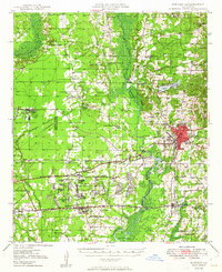
1949 Map of Minden
USGS Topo · Published 1949About this map
Minden and its surrounding parish lands are defined by a mix of early industrial development and rural community infrastructure during the late 1940s. The presence of the massive Louisiana Ordnance Plant south of town, along with the Bellevue Oilfield to the west, illustrates the region's mid-century shift toward military and energy production. Despite this industrial footprint, the landscape remains dotted with dozens of family-named landmarks and local institutions, from Jim Davis Cemetery to the Growing Valley School, reflecting deep-seated genealogical roots in the area.
Find a feature on this map
69 named features on this map. Tap any name to fly to it.
Don’t see what you’re looking for? This feature index may not catch every label — zoom into the map to look around manually.
Map Details
Editions of this 1949 Minden Map
This is the sole edition of this map. No revisions or reprints were ever made.
Other maps of this area
1922 · Sarepta
USGS Topo · 1:62,500
1924 · Sarepta
USGS Topo · 1:62,500
1932 · Bossier SE
USGS Topo · 1:31,680
1932 · Bossier NE
USGS Topo · 1:31,680
1938 · Arnsberg
USGS Topo · 1:31,680
1947 · Ringgold
USGS Topo · 1:62,500
1947 · Minden
USGS Topo · 1:62,500
1948 · Bossier City
USGS Topo · 1:62,500
1948 · Caspiana
USGS Topo · 1:62,500
1948 · Jamestown
USGS Topo · 1:62,500