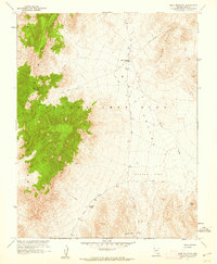
1961 Map of Mine Mountain
USGS Topo · Published 1962About this map
The Nevada Test Site occupies the majority of this 1961 topographical survey, conducted in cooperation with the Atomic Energy Commission during a period of intense activity in the high desert. The landscape is defined by the massive uplift of Shoshone Mountain and its Tiva Canyon, giving way to the high-elevation basin of Mid Valley. Strategically placed jeep trails and roads such as Saddle Road and Lookout Peak Rd navigate the difficult terrain, connecting remote points like Mine Mountain Junction and the prominent Jackass Divide. This map captures a strictly controlled military environment, where the topographic relief of Mine Mountain overlooks the appropriately named Barren Spot. The numerous benchmarks and survey points, including VABM Tip 4896, reflect the precise geodetic control required for operations in this corner of Nye County.
Find a feature on this map
25 named features on this map. Tap any name to fly to it.
Don’t see what you’re looking for? This feature index may not catch every label — zoom into the map to look around manually.
Map Details
Editions of this 1961 Mine Mountain Map
3 editions found
Other maps of this area

1908 · Kawich
USGS Topo · 1:250,000

1908 · Furnace Creek
USGS Topo · 1:250,000

1910 · Furnace Creek
USGS Topo · 1:250,000

1942 · Wheelbarrow Peak
USGS Topo · 1:125,000

1942 · Skull Mountain
USGS Topo · 1:125,000

1948 · Death Valley
USGS Topo · 1:250,000

1952 · Topopah Spring
USGS Topo · 1:62,500

1952 · Tippipah Spring
USGS Topo · 1:62,500

1952 · Timber Mountain
USGS Topo · 1:62,500
1952 · Cane Spring
USGS Topo · 1:62,500