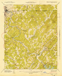
1943 Map of Mineral Bluff
USGS Topo · Published 1943About this map
Mineral Bluff serves as a central hub in this 1940s landscape where the borders of Georgia, Tennessee, and North Carolina converge. The Toccoa River dominates the geography, winding through Hogback Bend and feeding into the recently formed Lake Toccoa behind the Blue Ridge Dam. To the northwest, the industrial twin settlements of Copperhill and McCaysville straddle the state line, connected by the Louisville and Nashville railroad which follows the river's path through the mountains. This era shows a well-established rural infrastructure of small family-named landmarks and community centers. Genealogists will find numerous small burial grounds and places of worship, including Galloway Cem, Curtis Cem, and Shady Grove Ch. The presence of the Painwill Sch and various scattered settlements like Kyle and Hothouse reflects a period of localized mountain life before major highway expansion altered the regional transport patterns.
Find a feature on this map
77 named features on this map. Tap any name to fly to it.
Don’t see what you’re looking for? This feature index may not catch every label — zoom into the map to look around manually.
Map Details
Editions of this 1943 Mineral Bluff Map
This is the sole edition of this map. No revisions or reprints were ever made.
Other maps of this area

1888 · Ellijay
USGS Topo · 1:125,000

1892 · Ellijay
USGS Topo · 1:125,000

1893 · Murphy
USGS Topo · 1:125,000

1898 · Ellijay
USGS Topo · 1:125,000

1911 · Ellijay
USGS Topo · 1:125,000

1914 · Murphy
USGS Topo · 1:125,000

1934 · Persimmon Creek
USGS Topo · 1:24,000

1934 · Murphy
USGS Topo · 1:48,000

1935 · Epworth
USGS Topo · 1:24,000

1935 · Mineral Bluff
USGS Topo · 1:24,000