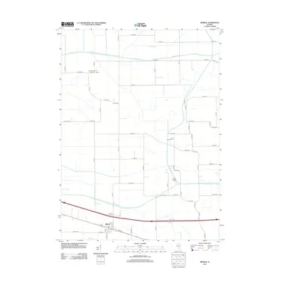
2012 Map of Mineral
USGS Topo · Published 2012About this map
The village of Mineral anchors the southern portion of this Illinois landscape, situated along a primary east-west rail and road corridor. This 2012 survey illustrates the grid of township roads that bisect the agricultural fields of Henry County, with Gold Township Cem providing a notable genealogical point of interest for local researchers. The northern reaches are defined by the Green River and the complex drainage patterns of Hunt Slough, while Etheridge Airport sits amidst the farmland to the west.
Find a feature on this map
42 named features on this map. Tap any name to fly to it.
Don’t see what you’re looking for? This feature index may not catch every label — zoom into the map to look around manually.
Map Details
Editions of this 2012 Mineral Map
This is the sole edition of this map. No revisions or reprints were ever made.
Other maps of this area

1921 · Buda
USGS Topo · 1:62,500

1923 · Buda
USGS Topo · 1:62,500

1929 · Annawan
USGS Topo · 1:62,500

1932 · Prophetstown
USGS Topo · 1:48,000

1932 · Annawan
USGS Topo · 1:62,500

1936 · Prophetstown
USGS Topo · 1:62,500

1949 · Walnut
USGS Topo · 1:62,500

1958 · Aurora
USGS Topo · 1:250,000

1961 · Aurora
USGS Topo · 1:250,000
1982 · New Bedford
USGS Topo · 1:24,000