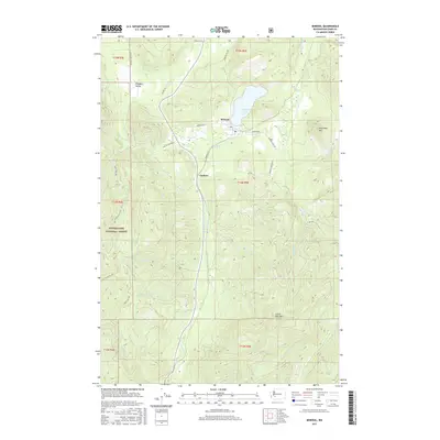
2017 Map of Mineral
USGS Topo · Published 2017About this map
Mineral sits at the northern heart of this landscape, its town center marked by the local Po and proximity to the expansive Mineral Lake. The area reflects a classic Pacific Northwest timber and mountain character, with the settlement of Carlson situated further south along the winding course of the Tilton River. This corridor is defined by its dramatic relief, rising from the river valley to prominent peaks such as Storm King Mtn and Roundtop Mtn. The western half of the map is dominated by the protected timberlands of the Snoqualmie National Forest, where a dense network of forest service roads like Nat For Dev Rd 74 provides access to the high country. Numerous drainages, including Summit Cr and East Cr, carve through the terrain, illustrating the complex watershed that feeds into the Tilton River system and supports the rural communities of Pleasant Valley and the Mineral area.
Find a feature on this map
38 named features on this map. Tap any name to fly to it.
Don’t see what you’re looking for? This feature index may not catch every label — zoom into the map to look around manually.
Map Details
Editions of this 2017 Mineral Map
This is the sole edition of this map. No revisions or reprints were ever made.
Other maps of this area

1937 · Eatonville
USGS Topo · 1:125,000

1941 · Tanwax Lake
USGS Topo · 1:62,500

1944 · Ohop Valley
USGS Topo · 1:62,500

1949 · Ohop Valley
USGS Topo · 1:62,500

1953 · Hoquiam
USGS Topo · 1:250,000

1956 · Mineral
USGS Topo · 1:62,500

1956 · Kapowsin
USGS Topo · 1:62,500

1957 · Hoquiam
USGS Topo · 1:250,000

1957 · Morton
USGS Topo · 1:62,500

1958 · Hoquiam
USGS Topo · 1:250,000