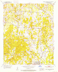
1951 Map of Mineral Springs North
USGS Topo · Published 1952About this map
The town of Mineral Springs anchors the southern portion of this Howard County landscape, which transitions into the rural communities of Midway and Temperanceville to the east. Surveyed in the early 1950s, the map reveals a network of country churches that served as focal points for local social life, including Trinity Ch, York Chapel, and Bluff Spring Ch. Transportation in this era relied on a combination of unimproved dirt roads and the rail lines of the Ash Down and Nashville and Graysonia Nashville and Ashdown railroads. The topography is defined by the winding course of Blue Bayou and its numerous tributaries such as Starch Creek and Dillard Creek. A notable concentration of community infrastructure is found at the County Line, where the County Line School and Shiloh Cem are situated alongside the gravel pits that likely provided materials for local road development.
Find a feature on this map
34 named features on this map. Tap any name to fly to it.
Don’t see what you’re looking for? This feature index may not catch every label — zoom into the map to look around manually.
Map Details
Editions of this 1951 Mineral Springs North Map
3 editions found
Other maps of this area

1906 · Caddo Gap
USGS Topo · 1:125,000

1913 · De Queen
USGS Topo · 1:125,000

1950 · Mcalester
USGS Topo · 1:250,000

1950 · Ben Lomond
USGS Topo · 1:24,000

1951 · Ben Lomond
USGS Topo · 1:24,000

1951 · Mineral Springs South
USGS Topo · 1:24,000

1951 · Columbus
USGS Topo · 1:24,000

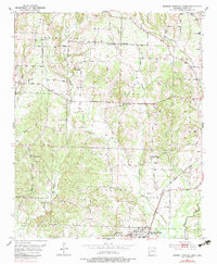
1951 · Mineral Springs North
USGS Topo · 1:24,000

1951 · Nashville
USGS Topo · 1:24,000

1951 · Silver Ridge
USGS Topo · 1:24,000