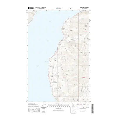
2013 Map of Minerva Peak
USGS Topo · Published 2013About this map
The eastern shore of Lake Pend Oreille defines this 2013 survey of the Idaho panhandle, where the rugged terrain of the Kanisku National Forest meets the water. Settlement is concentrated in small lakeside pockets such as Blacktail in the north and the cluster around Whiskey Rock further south. The map reveals a landscape heavily influenced by forestry and recreation, with a network of access points like Nat For Dev Rd 1050 and Cedar Creek Rd threading through the timbered slopes. High-elevation landmarks such as Minerva Peak and Minerva Ridge tower over the drainage basins of Canyon Cr and Falls Cr. Local history is anchored by the isolated Clara Cem near the shoreline, while geographic markers like Echo Rock and Granite Point highlight the dramatic geology of the Granite area.
Find a feature on this map
35 named features on this map. Tap any name to fly to it.
Don’t see what you’re looking for? This feature index may not catch every label — zoom into the map to look around manually.
Map Details
Editions of this 2013 Minerva Peak Map
This is the sole edition of this map. No revisions or reprints were ever made.
Other maps of this area

1901 · Sandpoint
USGS Topo · 1:125,000

1903 · Rathdrum
USGS Topo · 1:125,000

1909 · Cataldo
USGS Topo · 1:125,000

1911 · Cataldo
USGS Topo · 1:125,000

1911 · Priest Lake
USGS Topo · 1:250,000

1911 · Sandpoint
USGS Topo · 1:125,000

1913 · Priest Lake
USGS Topo · 1:250,000

1949 · Packsaddle Mtn
USGS Topo · 1:62,500

1951 · Packsaddle Mtn
USGS Topo · 1:62,500

1955 · Spokane
USGS Topo · 1:250,000