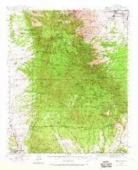
1944 Map of Mingus Mtn
USGS Topo · Published 1965About this map
The copper mining hub of Jerome anchors the northern slopes of Mingus Mountain, overlooking a landscape defined by 1940s industrial extraction and high-desert ranching. This mid-century survey captures the region's intense mineral history, with numerous workings like the Iron King Mine and Copper Chief Mine dotting the ridges of the Prescott National Forest. To the south, the settlement of Cherry and the Yarber Sch represent the more isolated pockets of residency, while Humboldt and Dewey sit along the Agua Fria River and the Atchison Topeka and Santa Fe railroad corridor. The presence of facilities like Clemenceau Airport and the Yaeger Canyon Ranger Sta illustrates the infrastructure required to manage these diverse forest and mineral lands during the war years.
Find a feature on this map
61 named features on this map. Tap any name to fly to it.
Don’t see what you’re looking for? This feature index may not catch every label — zoom into the map to look around manually.
Map Details
Editions of this 1944 Mingus Mtn Map
4 editions found

Other maps of this area

1887 · Verde
USGS Topo · 1:250,000

1887 · Prescott
USGS Topo · 1:250,000

1892 · Verde
USGS Topo · 1:250,000

1892 · Prescott
USGS Topo · 1:250,000

1903 · Bradshaw Mountains
USGS Topo · 1:125,000

1905 · Jerome
USGS Topo · 1:125,000

1923 · Camp Verde
USGS Topo · 1:125,000

1929 · Turret Peak
USGS Topo · 1:125,000

1932 · Camp Verde
USGS Topo · 1:125,000

1933 · Turret Peak
USGS Topo · 1:125,000