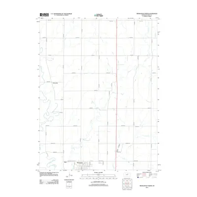
2012 Map of Minneapolis North
USGS Topo · Published 2012About this map
The Solomon River meanders across the western landscape of this Ottawa County region, defining a broad valley that has long supported the agricultural life of north-central Kansas. Near the southern boundary, the northern edge of Minneapolis serves as the primary hub, where a grid of streets including Pipe St and N Rock St meet the rural road network. Smaller localities such as Sumnerville and Alfmil anchor the surrounding townships, which are interconnected by a geometric lattice of named roads like Treaty Rd and Quaker Rd. The terrain is further drained by the intricate winding paths of Pipe Cr and Lindsey Cr, showing how the natural hydrology intersects with a landscape organized for farming and transit. This 2012 survey illustrates the enduring relationship between the river valley and the rural communities that maintain the township lines.
Find a feature on this map
37 named features on this map. Tap any name to fly to it.
Don’t see what you’re looking for? This feature index may not catch every label — zoom into the map to look around manually.
Map Details
Editions of this 2012 Minneapolis North Map
This is the sole edition of this map. No revisions or reprints were ever made.
Other maps of this area

1892 · Minneapolis
USGS Topo · 1:125,000

1952 · Glasco
USGS Topo · 1:24,000

1955 · Manhattan
USGS Topo · 1:250,000

1956 · Manhattan
USGS Topo · 1:250,000

1957 · Manhattan
USGS Topo · 1:250,000

1961 · Tescott NE
USGS Topo · 1:24,000

1964 · Lamar
USGS Topo · 1:24,000
1965 · Minneapolis South
USGS Topo · 1:24,000

1965 · Minneapolis North
USGS Topo · 1:24,000
1965 · Aurora SW
USGS Topo · 1:24,000