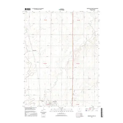
2016 Map of Minneapolis North
USGS Topo · Published 2016About this map
Minneapolis anchors the southern boundary of this Kansas landscape, where the street grid of the county seat meets the meandering course of the Solomon River. The terrain is defined by a dense network of drainage systems including Pipe Cr, Lindsey Cr, and Pine Cr, which carve through the agricultural uplands. Smaller named locations such as Summerville and Alfmil are situated along the river valley and regional roads, representing the historical settlement patterns of Ottawa County. A distinct section-line road system organizes the countryside, featuring descriptive names like Pioneer Rd, Quartz Rd, and Oxbow Rd. On the northeastern edge, the Hall Cem provides a specific point of interest for those researching local family histories and early burials. The map illustrates a contemporary rural environment where established municipal boundaries like t11s r4w intersect with the natural path of the river and its many tributaries.
Find a feature on this map
42 named features on this map. Tap any name to fly to it.
Don’t see what you’re looking for? This feature index may not catch every label — zoom into the map to look around manually.
Map Details
Editions of this 2016 Minneapolis North Map
This is the sole edition of this map. No revisions or reprints were ever made.
Other maps of this area

1892 · Minneapolis
USGS Topo · 1:125,000

1952 · Glasco
USGS Topo · 1:24,000

1955 · Manhattan
USGS Topo · 1:250,000

1956 · Manhattan
USGS Topo · 1:250,000

1957 · Manhattan
USGS Topo · 1:250,000

1961 · Tescott NE
USGS Topo · 1:24,000

1964 · Lamar
USGS Topo · 1:24,000
1965 · Minneapolis South
USGS Topo · 1:24,000

1965 · Minneapolis North
USGS Topo · 1:24,000
1965 · Aurora SW
USGS Topo · 1:24,000