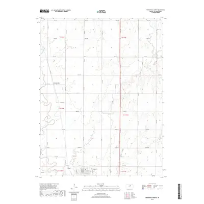
2018 Map of Minneapolis North
USGS Topo · Published 2018About this map
Minneapolis serves as the primary hub on this northern Ottawa County landscape, situated along the banks of the Solomon River. The terrain is defined by the subtle drainage patterns of Pipe Cr and Lindsey Cr, which flow through a structured grid of rural roads and section lines. Further north, the settlement of Summerville and the small siding or locality of Alfmil are visible, connected by a network of thoroughfares such as Treaty Rd and Sunset Rd. Genealogists and local historians will note the location of Hall Cem in the northeastern corner of the map, while the presence of Railroad St in the county seat hints at the legacy of the rail lines that once drove the regional economy. This survey documents a late-twentieth-century rural Kansas landscape where agrarian boundaries and watercourses dictate the flow of travel and settlement.
Find a feature on this map
48 named features on this map. Tap any name to fly to it.
Don’t see what you’re looking for? This feature index may not catch every label — zoom into the map to look around manually.
Map Details
Editions of this 2018 Minneapolis North Map
This is the sole edition of this map. No revisions or reprints were ever made.
Other maps of this area

1892 · Minneapolis
USGS Topo · 1:125,000

1952 · Glasco
USGS Topo · 1:24,000

1955 · Manhattan
USGS Topo · 1:250,000

1956 · Manhattan
USGS Topo · 1:250,000

1957 · Manhattan
USGS Topo · 1:250,000

1961 · Tescott NE
USGS Topo · 1:24,000

1964 · Lamar
USGS Topo · 1:24,000
1965 · Minneapolis South
USGS Topo · 1:24,000

1965 · Minneapolis North
USGS Topo · 1:24,000
1965 · Aurora SW
USGS Topo · 1:24,000