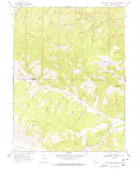
1969 Map of Minnie Maud Creek East
USGS Topo · Published 1978About this map
The high plateau landscape along the Duchesne Co Carbon Co boundary is defined by the deep incisions of Minnie Maud Creek and its many named tributaries. This 1969 field-checked survey reveals an era of resource exploration and water management in the region, noted by a Drill Hole near Pinnacle Canyon and a Gaging Station downstream from Pack Canyon. The topography is a complex network of ridges and draws, including Argyle Ridge and Minnie Maud Ridge, which provided natural corridors for travel. Local family and place names are preserved in features like Sorensen Draw, Brundage Cove, and Sorens Canyon. Higher elevations such as Whitmore Park are dotted with landmarks like Sky-high Pond, while the southern reaches of the map transition into the Nine Mile Creek drainage system, a vital water source for the surrounding high country.
Find a feature on this map
41 named features on this map. Tap any name to fly to it.
Don’t see what you’re looking for? This feature index may not catch every label — zoom into the map to look around manually.
Map Details
Editions of this 1969 Minnie Maud Creek East Map
2 editions found
Other maps of this area

1886 · Price River
USGS Topo · 1:250,000

1896 · Price River
USGS Topo · 1:250,000

1915 · Sunnyside
USGS Topo · 1:62,500

1915 · Wellington
USGS Topo · 1:62,500

1956 · Price
USGS Topo · 1:250,000

1960 · Price
USGS Topo · 1:250,000

1962 · Price
USGS Topo · 1:250,000
1968 · Lance Canyon
USGS Topo · 1:24,000

1968 · Wood Canyon
USGS Topo · 1:24,000
1968 · Anthro Mtn
USGS Topo · 1:24,000