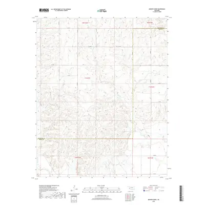
2018 Map of Minnow Creek
USGS Topo · Published 2018About this map
Minnow Creek and several significant tributaries define the hydrology of this Western Oklahoma landscape along the boundary of Beckham and Greer Counties. The topography is shaped by the drainage patterns of Fish Creek, Deer Creek, and Root Creek, which cut through the red-earth terrain typical of this region. A strictly organized grid of section-line roads, including N1750 Road and E1310 Road, underscores the rural agricultural framework established by the Public Land Survey System. The map documents a sparsely populated area where the intersection of D1378 Road and other local routes provides access to the surrounding ranchland and creek bottoms. This survey preserves the exact township and range divisions, such as t7n r25w, which remain fundamental to local land records and property history.
Find a feature on this map
25 named features on this map. Tap any name to fly to it.
Don’t see what you’re looking for? This feature index may not catch every label — zoom into the map to look around manually.
Map Details
Editions of this 2018 Minnow Creek Map
This is the sole edition of this map. No revisions or reprints were ever made.
Other maps of this area

1955 · Lawton
USGS Topo · 1:250,000

1955 · Clinton
USGS Topo · 1:250,000

1957 · Clinton
USGS Topo · 1:250,000

1961 · Willow
USGS Topo · 1:62,500

1961 · Erick
USGS Topo · 1:62,500
1971 · Madge
USGS Topo · 1:24,000

1971 · Vinson
USGS Topo · 1:24,000

1971 · Reed
USGS Topo · 1:24,000

1985 · Elk City
USGS Topo · 1:100,000

1985 · Altus
USGS Topo · 1:100,000