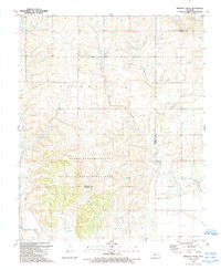
1989 Map of Minnow Creek
USGS Topo · Published 1989About this map
The Richland area of western Oklahoma exhibits a landscape defined by significant resource extraction and conservation efforts during the late twentieth century. A prominent Gas Field occupies the northern half of the territory, dotted with numerous Gas Wells and Oil Wells that highlight the regional energy economy. Further south, the terrain transitions into the protected expanse of the Sandy Sanders State Wildlife Management Area, which straddles the county line between Beckham and Greer counties. The hydrological network is anchored by the Elm Fork Red River in the south, fed by tributary systems including Minnow Creek, Deer Creek, and Fish Creek. Small-scale water features like Doc Hollis Lake provide localized points of interest for researchers tracing land use and environmental shifts in this part of the state.
Find a feature on this map
12 named features on this map. Tap any name to fly to it.
Don’t see what you’re looking for? This feature index may not catch every label — zoom into the map to look around manually.
Map Details
Editions of this 1989 Minnow Creek Map
This is the sole edition of this map. No revisions or reprints were ever made.
Other maps of this area

1955 · Lawton
USGS Topo · 1:250,000

1955 · Clinton
USGS Topo · 1:250,000

1957 · Clinton
USGS Topo · 1:250,000

1961 · Willow
USGS Topo · 1:62,500

1961 · Erick
USGS Topo · 1:62,500
1971 · Madge
USGS Topo · 1:24,000

1971 · Vinson
USGS Topo · 1:24,000

1971 · Reed
USGS Topo · 1:24,000

1985 · Elk City
USGS Topo · 1:100,000

1985 · Altus
USGS Topo · 1:100,000