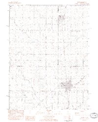
1983 Map of Minonk
USGS Topo · Published 1984About this map
The city of Minonk serves as the focal point of this 1980s landscape, where the Illinois Central Gulf and Atchison Topeka and Santa Fe rail lines converge. This corner of Illinois is defined by the intersection of Marshall, La Salle, and Woodford counties, a boundary complex that underscores the region's agricultural and administrative organization. Evidence of the area's coal history is visible in the mine dump located northwest of the main Minonk settlement, while local education and faith are represented by St Patricks Sch and several burial grounds, including St Patricks Cem and Rutland Cem. Smaller airfields like the Meils Landing Strip and Oltman Shuck Landing Strips highlight a reliance on light aviation across the prairie. The drainage of the land is meticulously mapped through the various branches of North Branch Crow Creek and South Branch Crow Creek.
Find a feature on this map
27 named features on this map. Tap any name to fly to it.
Don’t see what you’re looking for? This feature index may not catch every label — zoom into the map to look around manually.
Map Details
Editions of this 1983 Minonk Map
This is the sole edition of this map. No revisions or reprints were ever made.
Other maps of this area

1925 · Streator
USGS Topo · 1:62,500

1927 · Streator
USGS Topo · 1:62,500

1934 · Wenona
USGS Topo · 1:48,000

1939 · Wenona
USGS Topo · 1:62,500

1955 · Minonk
USGS Topo · 1:62,500

1958 · Flanagan
USGS Topo · 1:62,500

1958 · Aurora
USGS Topo · 1:250,000

1958 · Peoria
USGS Topo · 1:250,000

1961 · Aurora
USGS Topo · 1:250,000

1961 · Peoria
USGS Topo · 1:250,000