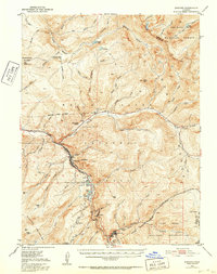
1934 Map of Minturn
USGS Topo · Published 1952About this map
Mining and military operations define the Eagle River valley in this mid-century survey, which focuses on the rugged corridor between Minturn and Red Cliff. The Denver and Rio Grande Western Railroad winds through the canyon, serving the elevated mining community of Gilman and the nearby operations at Belden. This era shows the landscape shaped by industry and defense, most notably with the presence of the Camp Hale Military Reservation sprawling across the southern portion of the sheet. High mountain terrain, including the Sawatch Mountains and the Gore Range, surrounds these narrow industrial hubs. Local life is visible in the placement of the Gore Creek School and the Minturn Ranger Sta, while the Liberty Mine (Aband) near Iron Mountain reflects the changing nature of mineral extraction in the high Rockies.
Find a feature on this map
70 named features on this map. Tap any name to fly to it.
Don’t see what you’re looking for? This feature index may not catch every label — zoom into the map to look around manually.
Map Details
Editions of this 1934 Minturn Map
5 editions found
Other maps of this area

1889 · Leadville
USGS Topo · 1:125,000

1891 · Leadville
USGS Topo · 1:125,000

1909 · Mount Jackson
USGS Topo · 1:125,000

1911 · Mount Jackson
USGS Topo · 1:125,000

1929 · Dillon
USGS Topo · 1:62,500

1933 · Mt. Powell
USGS Topo · 1:48,000

1933 · Ute Peak
USGS Topo · 1:62,500

1934 · Climax
USGS Topo · 1:48,000

1934 · Minturn
USGS Topo · 1:62,500

1934 · Dillon
USGS Topo · 1:62,500