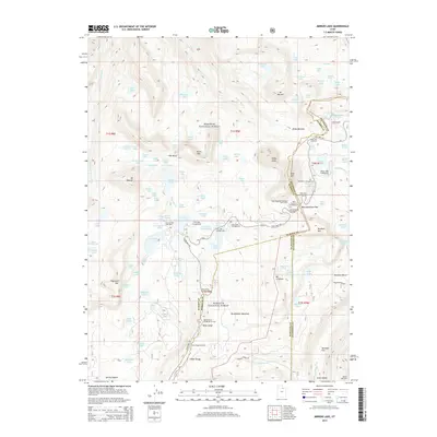
2014 Map of Mirror Lake
USGS Topo · Published 2014About this map
Wasatch National Forest dominates this high-altitude landscape where the headwaters of several major river systems emerge. The corridor following State Hwy 150 serves as the primary artery for high-country access, connecting a dense network of alpine recreational sites such as Mirror Lake Campground and the historic Camp Steiner. The map documents a complex hydrological divide where the Weber River and Duchesne River begin their respective journeys, carved out by glacial features like The Notch and the dramatic drop of Slate Gorge. From the peak of Bald Mtn to the expansive Broadwater Meadows, the terrain illustrates a classic Western wilderness management area, defined by its numerous glacial lakes including Trident Lake, Cuberant Lake, and the well-known Mirror Lake.
Find a feature on this map
118 named features on this map. Tap any name to fly to it.
Don’t see what you’re looking for? This feature index may not catch every label — zoom into the map to look around manually.
Map Details
Editions of this 2014 Mirror Lake Map
This is the sole edition of this map. No revisions or reprints were ever made.
Other maps of this area

1885 · Salt Lake
USGS Topo · 1:250,000

1885 · Uinta
USGS Topo · 1:250,000

1900 · Coalville
USGS Topo · 1:125,000

1901 · Hayden Peak
USGS Topo · 1:125,000

1903 · Hayden Peak
USGS Topo · 1:125,000

1903 · Coalville
USGS Topo · 1:125,000

1954 · Salt Lake City
USGS Topo · 1:250,000

1958 · Salt Lake City
USGS Topo · 1:250,000

1960 · Salt Lake City
USGS Topo · 1:250,000
1972 · Iron Mine Mountain
USGS Topo · 1:24,000