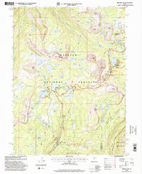
1998 Map of Mirror Lake
USGS Topo · Published 2001About this map
Wasatch National Forest dominates this alpine landscape, characterized by a dense concentration of glacial lakes and dramatic peaks along the western edge of the High Uintas Wilderness. The map reveals an intensive recreational infrastructure centered around the Mirror Lake Scenic Byway, where developed sites like the Mirror Lake Campgrounds and Picnic Area and Moosehorn Campgrounds provide access to the high-elevation terrain. Notable summits including Bald Mountain and Notch Mountain overlook a network of water bodies such as Cuberant Lake, Ibantik Lake, and Lake Marion. The presence of the Mirror Lake Guard Sta and the Bald Mountain Radio Repeater underscores the administrative and communications importance of this rugged corridor within the Wasatch Mountain range.
Find a feature on this map
102 named features on this map. Tap any name to fly to it.
Don’t see what you’re looking for? This feature index may not catch every label — zoom into the map to look around manually.
Map Details
Editions of this 1998 Mirror Lake Map
This is the sole edition of this map. No revisions or reprints were ever made.
Other maps of this area

1885 · Salt Lake
USGS Topo · 1:250,000

1885 · Uinta
USGS Topo · 1:250,000

1900 · Coalville
USGS Topo · 1:125,000

1901 · Hayden Peak
USGS Topo · 1:125,000

1903 · Hayden Peak
USGS Topo · 1:125,000

1903 · Coalville
USGS Topo · 1:125,000

1954 · Salt Lake City
USGS Topo · 1:250,000

1958 · Salt Lake City
USGS Topo · 1:250,000

1960 · Salt Lake City
USGS Topo · 1:250,000
1972 · Iron Mine Mountain
USGS Topo · 1:24,000