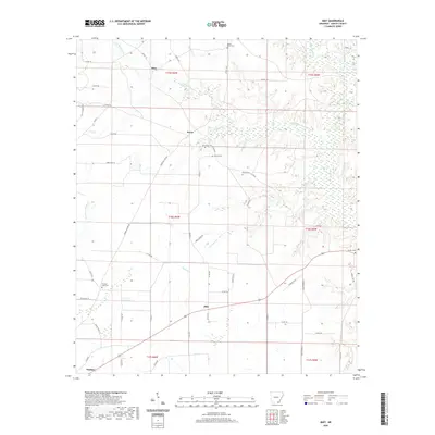
2020 Map of Mist
USGS Topo · Published 2020About this map
Mist and Berea center this Arkansas landscape, where small rural settlements are tied together by a network of county roads like Co Rd 66 and James Stone Rd. The terrain is defined by a dense web of slow-moving waterways, including the winding Little Bearhouse Cr and Jackson Cr, which snake through the southeastern Ashley County plains. Local history is deeply rooted here, as evidenced by several family and community burial sites scattered across the township lines. Genealogists can identify precise locations for the Promise Land Cem, Griswould Cem, and Mount Olive Cem. The drainage patterns, such as Chemin-A-Haut Cr and Mullis Br, suggest a landscape shaped by intermittent creek beds and low-lying wetlands, while the road names like Hunting Club point to the area's contemporary land use and social character.
Find a feature on this map
62 named features on this map. Tap any name to fly to it.
Don’t see what you’re looking for? This feature index may not catch every label — zoom into the map to look around manually.
Map Details
Editions of this 2020 Mist Map
This is the sole edition of this map. No revisions or reprints were ever made.
Other maps of this area

1935 · Mist
USGS Topo · 1:62,500

1935 · Wilmot
USGS Topo · 1:62,500

1952 · Fountain Hill
USGS Topo · 1:24,000

1953 · Greenwood
USGS Topo · 1:250,000

1956 · Greenwood
USGS Topo · 1:250,000

1960 · Snyder
USGS Topo · 1:24,000

1960 · Mist
USGS Topo · 1:62,500

1960 · Wilmot
USGS Topo · 1:62,500
1960 · Portland
USGS Topo · 1:24,000

1960 · Wilmot NW
USGS Topo · 1:24,000