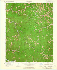
1953 Map of Mistletoe
USGS Topo · Published 1966About this map
Mistletoe and Sebastian are part of a dense network of isolated hollows and ridgetop settlements where Owsley, Perry, Clay, and Breathitt Counties meet. The landscape in the early 1950s is defined by a reliance on local schoolhouses and family burial grounds, with Rockhouse Sch, Lucky Fork Sch, and the Sandlin Sch serving these scattered communities. Many homes are situated along winding waterways like Buffalo Creek and Little Bullskin Creek, reflecting the traditional Kentucky mountain settlement pattern where valley floors provide the primary corridor for movement. The presence of Oil Wells and a Gas Well near the headwaters of Bullskin Creek indicates the early development of mineral resources alongside more established agrarian life. Prominent terrain features like Courthouse Rock and Bald Head Hol provide natural orientation points in a territory where the creek branches — including the curiously named Whoopflarea Br and Barbecue Branch — dictate the shape of every road and farmstead.
Find a feature on this map
111 named features on this map. Tap any name to fly to it.
Don’t see what you’re looking for? This feature index may not catch every label — zoom into the map to look around manually.
Map Details
Editions of this 1953 Mistletoe Map
2 editions found

Other maps of this area

1891 · Manchester
USGS Topo · 1:125,000

1891 · Hazard
USGS Topo · 1:125,000

1913 · Buckhorn
USGS Topo · 1:62,500

1916 · Hyden
USGS Topo · 1:48,000

1919 · Hyden
USGS Topo · 1:62,500

1953 · Buckhorn
USGS Topo · 1:24,000

1953 · Oneida
USGS Topo · 1:24,000

1953 · Cowcreek
USGS Topo · 1:24,000

1953 · Hyden West
USGS Topo · 1:24,000

1953 · Big Creek
USGS Topo · 1:24,000