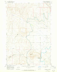
1967 Map of Mitchell Butte
USGS Topo · Published 1971About this map
Mitchell Butte dominates this high-desert landscape in eastern Malheur County, where the 1960s irrigation infrastructure of the Owyhee Project is meticulously documented. The complex engineering required to move water through this arid terrain is visible through features like the North Canal, the Cow Hollow Siphon, and Tunnel No 4. Along the southern edge, the Owyhee River carves through the basin, flanked by landmarks such as Mitchell Butte Hot Spring and the Owyhee Ditch. A network of rural avenues including Ivanhoe Ave and Klamath Avenue grids the flatter eastern benches, transitioning into the more varied topography of Chalk Butte and Fletcher Gulch. The map also captures several landing strips and local landmarks like Rock Spring, reflecting the area's remote ranching and agricultural character.
Find a feature on this map
40 named features on this map. Tap any name to fly to it.
Don’t see what you’re looking for? This feature index may not catch every label — zoom into the map to look around manually.
Map Details
Editions of this 1967 Mitchell Butte Map
2 editions found
Other maps of this area

1906 · Mitchell Butte
USGS Topo · 1:125,000

1955 · Boise
USGS Topo · 1:250,000

1958 · Boise
USGS Topo · 1:250,000

1962 · Boise
USGS Topo · 1:250,000
1967 · Vale East
USGS Topo · 1:24,000
1967 · Cairo
USGS Topo · 1:24,000
1967 · Owyhee Dam
USGS Topo · 1:24,000
1967 · Vale West
USGS Topo · 1:24,000
1967 · Double Mtn
USGS Topo · 1:24,000
1967 · Adrian
USGS Topo · 1:24,000