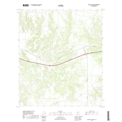
2019 Map of Mitchell Canyon NE
USGS Topo · Published 2019About this map
Eureka Draw carves a path through this section of Crockett County, defining the drainage patterns of a landscape marked by intricate topographic relief. The area is a nexus of regional transit, where the modern corridor of Interstate 10 intersects with secondary routes such as Ranch Rd 2398 and RM 2083. In the southern reaches, the infrastructure transitions to more localized thoroughfares like Pandale Rd and Co Rd 403. This map illustrates the intersection of high-speed transportation and the complex natural erosion features of the Texas Edwards Plateau region.
Find a feature on this map
5 named features on this map. Tap any name to fly to it.
Don’t see what you’re looking for? This feature index may not catch every label — zoom into the map to look around manually.
Map Details
Editions of this 2019 Mitchell Canyon NE Map
This is the sole edition of this map. No revisions or reprints were ever made.
Other maps of this area

1954 · Sonora
USGS Topo · 1:250,000

1958 · Sonora
USGS Topo · 1:250,000

1967 · Ozona
USGS Topo · 1:24,000

1967 · Baggett Ranch
USGS Topo · 1:24,000

1967 · Pikes Peak
USGS Topo · 1:24,000
1967 · Schneeman Draw SW
USGS Topo · 1:24,000

1967 · Indio Hill
USGS Topo · 1:24,000

1967 · Hunt Ranch
USGS Topo · 1:24,000
1967 · Schneeman Draw SE
USGS Topo · 1:24,000
1967 · Mitchell Canyon NE
USGS Topo · 1:24,000