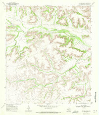
1969 Map of Mitchell Draw
USGS Topo · Published 1972About this map
Mitchell Draw and the serpentine Independence Creek define the arid topography of this West Texas landscape in Terrell County. The 1969 survey, field-checked just as the decade closed, reveals a terrain shaped by dramatic elevation changes and intermittent watercourses. Human impact on the land is sparse but industrial, evidenced by a long Pipeline cutting across the northern reaches and a localized Gravel Pit near the center of the sheet. The network of unimproved roads and fence lines suggests a vast ranching economy where water is the primary concern, noted by the occasional Well located far from the main drainage of Seventeen Draw. These ephemeral waterways and draws are the primary landmarks in an area where the natural geography dictates the sparse settlement patterns of the late twentieth century.
Find a feature on this map
6 named features on this map. Tap any name to fly to it.
Don’t see what you’re looking for? This feature index may not catch every label — zoom into the map to look around manually.
Map Details
Editions of this 1969 Mitchell Draw Map
This is the sole edition of this map. No revisions or reprints were ever made.
Other maps of this area

1928 · Sanderson
USGS Topo · 1:125,000

1929 · Sheffield
USGS Topo · 1:125,000

1929 · Independence Draw Quadrangle
USGS Topo · 1:125,000

1954 · Fort Stockton
USGS Topo · 1:250,000

1954 · Sonora
USGS Topo · 1:250,000

1958 · Sonora
USGS Topo · 1:250,000

1958 · Fort Stockton
USGS Topo · 1:250,000

1967 · Sheffield NW
USGS Topo · 1:24,000

1967 · Horsehead Canyon
USGS Topo · 1:24,000

1969 · Circle Dot Ranch
USGS Topo · 1:24,000