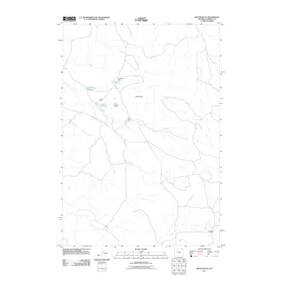
2011 Map of Mitten Butte
USGS Topo · Published 2011About this map
Trail Creek Ranch and the prominence of Mitten Butte anchor this section of northeast Wyoming, where water management defines the arid landscape. The map details a sophisticated network of small-scale irrigation and stock water systems, including Gary Reservoir, North Trail Reservoir, and Donna Reservoir. These man-made features, supported by structures like Parks Number 1 Dam, emphasize the necessity of water storage for ranching operations in a region drained by seasonal flows like Prairie Dog Creek and Trail Creek.
Find a feature on this map
17 named features on this map. Tap any name to fly to it.
Don’t see what you’re looking for? This feature index may not catch every label — zoom into the map to look around manually.
Map Details
Editions of this 2011 Mitten Butte Map
This is the sole edition of this map. No revisions or reprints were ever made.
Other maps of this area

1954 · Ekalaka
USGS Topo · 1:250,000

1954 · Gillette
USGS Topo · 1:250,000

1955 · Gillette
USGS Topo · 1:250,000

1956 · Ekalaka
USGS Topo · 1:250,000

1958 · Gillette
USGS Topo · 1:250,000

1958 · Ekalaka
USGS Topo · 1:250,000

1962 · Gillette
USGS Topo · 1:250,000

1965 · Ekalaka
USGS Topo · 1:250,000
1970 · Belle Creek South
USGS Topo · 1:24,000

1970 · Belle Creek SW
USGS Topo · 1:24,000