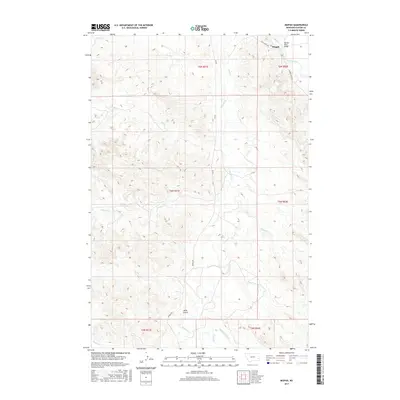
2017 Map of Mizpah
USGS Topo · Published 2017About this map
Mizpah serves as a lonely point of reference in this landscape of Custer County, situated near the winding course of the Powder River. The geography is defined by a dense network of intermittent drainages, including First Cr, Second Cr, and the central Mizpah Cr, which carve through the high plains. Human activity is sparse, marked primarily by the local road network such as Trail Creek Rd and Mizpah Rd, and the critical Powder River Bridge providing passage in the northeast. The terrain reveals its character through descriptive labels like Hells Gulch and a series of creeks including Fivemile Cr, Russell Cr, and Fessler Cr. This survey illustrates the ranching-oriented land use and the reliance on natural drainage patterns for navigation and settlement in the eastern Montana plains.
Find a feature on this map
22 named features on this map. Tap any name to fly to it.
Don’t see what you’re looking for? This feature index may not catch every label — zoom into the map to look around manually.
Map Details
Editions of this 2017 Mizpah Map
This is the sole edition of this map. No revisions or reprints were ever made.
Other maps of this area

1953 · Miles City
USGS Topo · 1:250,000

1957 · Miles City
USGS Topo · 1:250,000

1958 · Miles City
USGS Topo · 1:250,000

1969 · Mizpah
USGS Topo · 1:24,000

1969 · Loaf of Bread Butte
USGS Topo · 1:24,000

1969 · Forty Creek
USGS Topo · 1:24,000

1969 · Locate SE
USGS Topo · 1:24,000

1969 · Miles City Creek
USGS Topo · 1:24,000
1969 · Pennock Creek
USGS Topo · 1:24,000
1969 · Red Knob
USGS Topo · 1:24,000