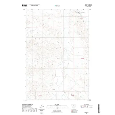
2020 Map of Mizpah
USGS Topo · Published 2020About this map
Mizpah sits at the northern edge of this high-plains landscape, where the Powder River cuts across the northeastern corner of Custer County. This drainage basin is defined by an intricate network of seasonal waterways, including the winding Mizpah Cr and several numbered or named tributaries like Second Cr and Fivemile Cr. The crossing at Powder River Bridge and the path of Trail Creek Rd highlight the essential transportation corridors in this sparsely settled region. In the southern portion of the quadrangle, the terrain becomes more varied as it drops into Hells Gulch and the headwaters of Double Corral Cr and Timothy Cr. The map's township and range divisions, such as t5n r51e, illustrate the grid-based land management of the Montana ranchlands, where cattle movement and water access are dictated by the deep draws of Russell Cr and Fessler Cr.
Find a feature on this map
24 named features on this map. Tap any name to fly to it.
Don’t see what you’re looking for? This feature index may not catch every label — zoom into the map to look around manually.
Map Details
Editions of this 2020 Mizpah Map
This is the sole edition of this map. No revisions or reprints were ever made.
Other maps of this area

1953 · Miles City
USGS Topo · 1:250,000

1957 · Miles City
USGS Topo · 1:250,000

1958 · Miles City
USGS Topo · 1:250,000

1969 · Mizpah
USGS Topo · 1:24,000

1969 · Loaf of Bread Butte
USGS Topo · 1:24,000

1969 · Forty Creek
USGS Topo · 1:24,000

1969 · Locate SE
USGS Topo · 1:24,000

1969 · Miles City Creek
USGS Topo · 1:24,000
1969 · Pennock Creek
USGS Topo · 1:24,000
1969 · Red Knob
USGS Topo · 1:24,000