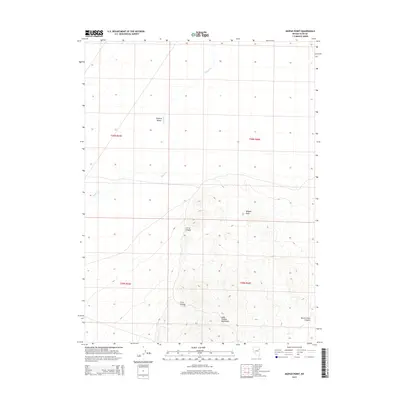
2015 Map of Mizpah Point
USGS Topo · Published 2015About this map
The Dolly Varden Mountains dominate the southern half of this map, rising sharply from the eastern edge of the Steptoe Valley. This high-desert landscape is defined by its dramatic relief, where the steep terrain is carved by multiple drainages including Corral Canyon and Crow Canyon. Water sources are few and vital in this arid environment, marked by the intermittent flow of Nelson Cr and the presence of Grouse Spring tucked within the mountain slopes. To the northeast, Mizpah Point stands as a prominent overlook. The topography reflects the classic Basin and Range geology of Elko County, where seasonal drainages like North Cr flow through North Creek Canyon toward the broad valley floors. This survey provides a clear view of the undeveloped land as it appeared in the early 21st century.
Find a feature on this map
13 named features on this map. Tap any name to fly to it.
Don’t see what you’re looking for? This feature index may not catch every label — zoom into the map to look around manually.
Map Details
Editions of this 2015 Mizpah Point Map
This is the sole edition of this map. No revisions or reprints were ever made.
Other maps of this area

1953 · Spruce Mountain 4
USGS Topo · 1:62,500

1955 · Elko
USGS Topo · 1:250,000

1958 · Elko
USGS Topo · 1:250,000

1962 · Elko
USGS Topo · 1:250,000

1965 · Elko
USGS Topo · 1:250,000

1972 · Decoy SW
USGS Topo · 1:24,000

1982 · Currie
USGS Topo · 1:24,000

1982 · Sharp Peak
USGS Topo · 1:24,000
1982 · Dolly Varden Spring
USGS Topo · 1:24,000
1982 · White Horse Mountain NW
USGS Topo · 1:24,000