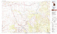
1983 Map of Moab
USGS Topo · Published 1983About this map
Arches National Park dominates the central landscape of this 1983 survey, showcasing a high concentration of geologic landmarks including Delicate Arch, Landscape Arch, and the Tower of Babel. The mapping captures the region during a period of transition, where the legacy of uranium mining is evidenced by the Telluride Mines and Cactus Rat Mine near the Denver and Rio Grande Western RR. The town of Moab serves as the primary hub along the Colorado River, connected to outlying settlements like Potash and the rail stops at Cisco and Thompson. Beyond the canyon floors, the map details the high mesa country of the Dome Plateau and Polar Mesa, while the southern reaches extend into the Manti-La Sal National Forest. This document provides a record of the intricate trail and road networks used for both extraction and early recreation in the red rock country before modern expansion.
Find a feature on this map
83 named features on this map. Tap any name to fly to it.
Don’t see what you’re looking for? This feature index may not catch every label — zoom into the map to look around manually.
Map Details
Editions of this 1983 Moab Map
3 editions found
Other maps of this area

1885 · San Rafael
USGS Topo · 1:250,000

1885 · East Tavaputs
USGS Topo · 1:250,000

1885 · La Sal
USGS Topo · 1:250,000

1886 · Price River
USGS Topo · 1:250,000

1896 · Price River
USGS Topo · 1:250,000

1916 · Paradox Valley
USGS Topo · 1:125,000

1922 · Paradox Valley
USGS Topo · 1:125,000

1948 · Roc Creek
USGS Topo · 1:24,000

1949 · Roc Creek
USGS Topo · 1:24,000

1949 · Juanita Arch
USGS Topo · 1:24,000