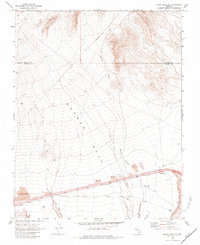
1969 Map of Moapa Peak SE
USGS Topo · Published 1984About this map
Mormon Mesa dominates this desert landscape in the late 1960s, its flat-topped expanse bisected by modern infrastructure and ancient routes. The historic Old Spanish Trail follows a path roughly parallel to the emerging interstate corridor, providing a tangible link to 19th-century trade routes across the Mojave. Industrial activity is evident through numerous Borrow Pits and a Gravel Pit along the southern portion of the sheet, while a solitary Corral and Prospect to the north indicate more traditional land uses.
Find a feature on this map
16 named features on this map. Tap any name to fly to it.
Don’t see what you’re looking for? This feature index may not catch every label — zoom into the map to look around manually.
Map Details
Editions of this 1969 Moapa Peak SE Map
2 editions found
Other maps of this area

1886 · Saint Thomas
USGS Topo · 1:250,000

1893 · Saint Thomas
USGS Topo · 1:250,000

1954 · Las Vegas
USGS Topo · 1:250,000

1957 · Las Vegas
USGS Topo · 1:250,000

1957 · Mesquite
USGS Topo · 1:62,500

1958 · Virgin Peak
USGS Topo · 1:62,500

1958 · Overton
USGS Topo · 1:62,500

1959 · Las Vegas
USGS Topo · 1:250,000

1962 · Las Vegas
USGS Topo · 1:250,000
1969 · Moapa Peak
USGS Topo · 1:24,000