
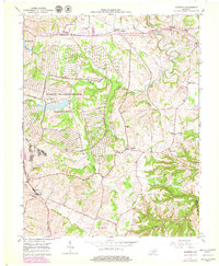
1952 Map of Moberly
USGS Topo · Published 1961About this map
The Blue Grass Ordnance Depot dominates the western landscape of this mid-century Madison County survey, its extensive network of bunkers and service roads carved into the terrain south of Moberly. This U S Military Reservation represents a significant wartime and post-war infrastructure presence, contrasting with the agrarian patterns to the east. Outside the depot, the community life of central Kentucky is preserved through a dense network of country schools and churches, including Concord Sch, Waco Sch, and Goodloe Chapel.
Find a feature on this map
31 named features on this map. Tap any name to fly to it.
Don’t see what you’re looking for? This feature index may not catch every label — zoom into the map to look around manually.
Map Details
Editions of this 1952 Moberly Map
2 editions found
Other maps of this area

1892 · Richmond
USGS Topo · 1:125,000

1897 · Richmond
USGS Topo · 1:125,000

1952 · Alcorn
USGS Topo · 1:24,000

1952 · Berea
USGS Topo · 1:24,000

1952 · Union City
USGS Topo · 1:24,000

1952 · Palmer
USGS Topo · 1:24,000

1952 · Richmond North
USGS Topo · 1:24,000

1952 · Bighill
USGS Topo · 1:24,000

1952 · Panola
USGS Topo · 1:24,000

1953 · Richmond South
USGS Topo · 1:24,000