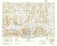
1953 Map of Moberly
USGS Topo · Published 1953About this map
The Missouri River carves a sweeping path through the heart of north-central Missouri, defining the landscape between Lexington and the high bluffs at Glasgow. This mid-century survey illustrates a complex web of river-and-rail commerce, where the Wabash Railroad and Atchison Topeka and Santa Fe Railway intersect near key agricultural hubs like Moberly and Carrollton. The drainage patterns of the Grand River, Chariton River, and the various forks of the Salt River reveal the intricate hydrology of the region, punctuated by wetlands like Swan Lake and local landmarks such as Blue Mound.
Find a feature on this map
249 named features on this map. Tap any name to fly to it.
Don’t see what you’re looking for? This feature index may not catch every label — zoom into the map to look around manually.
Map Details
Editions of this 1953 Moberly Map
This is the sole edition of this map. No revisions or reprints were ever made.
Other maps of this area
1885 · Warrensburg
USGS Topo · 1:125,000

1886 · Jefferson City
USGS Topo · 1:125,000

1887 · Harrisonville
USGS Topo · 1:125,000
1887 · Sedalia
USGS Topo · 1:125,000
1887 · Warrensburg
USGS Topo · 1:125,000
1888 · Boonville
USGS Topo · 1:125,000
1889 · Lexington
USGS Topo · 1:125,000
1890 · Mexico
USGS Topo · 1:125,000

1890 · Moberly
USGS Topo · 1:125,000
1890 · Glasgow
USGS Topo · 1:125,000