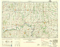
1957 Map of Moberly
USGS Topo · Published 1957About this map
The Missouri River anchors the southern reaches of this landscape, winding past riverfront towns like Lexington and Brunswick during an era when heavy rail still dominated the Missouri interior. This 1949 compilation, reprinted in 1957, reveals a complex network of transportation and water. Numerous lines including the Wabash RR, Santa Fe RR, and Missouri Pacific RR intersect at hub settlements like Moberly and Chillicothe, while the Grand River, Chariton River, and Salt River systems define the drainage of the north-central counties. The map illustrates the region's transition from river-dependent commerce to a rail-and-highway economy, with the path of the Missouri River serving as a primary geographic boundary between counties such as Carroll and Saline. Notable landmarks like Blue Mound stand out against the detailed riparian terrain of the Mussel Fork and Medicine Creek valleys.
Find a feature on this map
90 named features on this map. Tap any name to fly to it.
Don’t see what you’re looking for? This feature index may not catch every label — zoom into the map to look around manually.
Map Details
Editions of this 1957 Moberly Map
This is the sole edition of this map. No revisions or reprints were ever made.
Other maps of this area
1885 · Warrensburg
USGS Topo · 1:125,000

1886 · Jefferson City
USGS Topo · 1:125,000

1887 · Harrisonville
USGS Topo · 1:125,000
1887 · Sedalia
USGS Topo · 1:125,000
1887 · Warrensburg
USGS Topo · 1:125,000
1888 · Boonville
USGS Topo · 1:125,000
1889 · Lexington
USGS Topo · 1:125,000
1890 · Mexico
USGS Topo · 1:125,000

1890 · Moberly
USGS Topo · 1:125,000
1890 · Glasgow
USGS Topo · 1:125,000