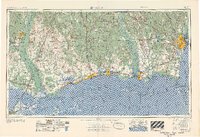
1957 Map of Mobile
USGS Topo · Published 1957About this map
The northern Gulf Coast waterfront spans from the marshes of Lake Pontchartrain across the Mississippi Sound to the vital port of Mobile. This mid-century survey captures the region's intense maritime and military character, anchored by Keesler Air Force Base in Biloxi and Brookley Air Force Base on the western shore of Mobile Bay. The landscape is defined by the great river systems of the Pearl River, the Pascagoula River, and the Mobile River, which supported the timber and industrial economies of settlements like Bogalusa and Moss Point.
Find a feature on this map
225 named features on this map. Tap any name to fly to it.
Don’t see what you’re looking for? This feature index may not catch every label — zoom into the map to look around manually.
Map Details
Editions of this 1957 Mobile Map
3 editions found

Other maps of this area

1891 · Spanish Fort
USGS Topo · 1:62,500

1891 · New Orleans
USGS Topo · 1:62,500

1892 · Chef Menteur
USGS Topo · 1:62,500

1892 · St. Bernard
USGS Topo · 1:62,500

1893 · Cat Island
USGS Topo · 1:62,500

1893 · Rigolets
USGS Topo · 1:62,500

1893 · Chandeleur
USGS Topo · 1:62,500

1893 · Shell Beach
USGS Topo · 1:62,500

1893 · Toulme
USGS Topo · 1:62,500

1895 · Bodreau
USGS Topo · 1:62,500