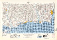
1957 Map of Mobile
USGS Topo · Published 1957About this map
Mobile and the northern Gulf Coast reveal a landscape defined by shipping channels and timbered interior lands during the mid-1950s. The coastline is a continuous stretch of development from Bay St Louis through Biloxi to Pascagoula, where the Intracoastal Waterway and Mobile Bay Channel facilitate heavy maritime traffic. Military and industrial infrastructure is prominent at the Theodore Ammunition Terminal U S Army and Brookley AFB, while the barrier islands including Cat Island, Ship Island, and Horn Island shield the Mississippi Sound.
Find a feature on this map
192 named features on this map. Tap any name to fly to it.
Don’t see what you’re looking for? This feature index may not catch every label — zoom into the map to look around manually.
Map Details
Editions of this 1957 Mobile Map
3 editions found

Other maps of this area

1891 · Spanish Fort
USGS Topo · 1:62,500

1891 · New Orleans
USGS Topo · 1:62,500

1892 · Chef Menteur
USGS Topo · 1:62,500

1892 · St. Bernard
USGS Topo · 1:62,500

1893 · Cat Island
USGS Topo · 1:62,500

1893 · Rigolets
USGS Topo · 1:62,500

1893 · Chandeleur
USGS Topo · 1:62,500

1893 · Shell Beach
USGS Topo · 1:62,500

1893 · Toulme
USGS Topo · 1:62,500

1895 · Bodreau
USGS Topo · 1:62,500