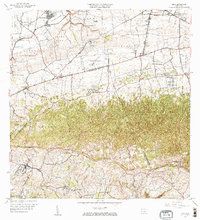
1964 Map of Moca
USGS Topo · Published 1967About this map
The town of Moca serves as a focal point in this 1960s landscape, where the agricultural traditions of northwest Puerto Rico meet expanding mid-century infrastructure. The terrain is dramatically bisected by the Cordillera Jaicoa, with numerous named peaks such as Monte Mariquilla and Monte El Ojo rising above the surrounding barrios. Significant hydraulic engineering is evident through a network of canals, including the Canal Principal de Riego de Isabela, and a series of power stations from Central Hidroelectrica No 1 to No 3. Local life is anchored by institutions like the Escuela Segunda Unidad de Voladoras and several country churches, including Iglesia Ceiba Alta. The map also captures the transition of transportation, noting the Antigua Via del Ferrocarril alongside the emerging modern road network and the northern influence of the Ramey Air Force Base.
Find a feature on this map
77 named features on this map. Tap any name to fly to it.
Don’t see what you’re looking for? This feature index may not catch every label — zoom into the map to look around manually.
Map Details
Editions of this 1964 Moca Map
3 editions found
Other maps of this area

1937 · Aguadilla
USGS Topo · 1:20,000

1937 · Moca
USGS Topo · 1:20,000

1938 · Alto Sano
USGS Topo · 1:20,000

1938 · San Sebastian
USGS Topo · 1:20,000

1938 · Quebradillas
USGS Topo · 1:20,000

1941 · Moca
USGS Topo · 1:30,000

1941 · Rincon
USGS Topo · 1:30,000

1941 · Rincon
USGS Topo · 1:30,000

1941 · Isabela
USGS Topo · 1:30,000

1941 · San Sebastian
USGS Topo · 1:30,000
Featured Places
- Moca
- Sector Los Laureles, Aguadilla
- Reparto Méndez, Isabela
- Reparto Santa María, Aguadilla
- Sector Nieves, Moca